Recentemente ho avuto l’opportunità di testare in volo un GPS logger commerciale che mi ha consigliato Roberto Petagna di Aviopress, il quale ha avviato una vera e propria sperimentazione su questo tipo di apparati. Il GPS logger è un device del tutto simile ad un’antenna GPS utilizzata via bluetooth (BT) dagli smartphone dotati di software di navigazione (tipo Tom Tom o Route66). A differenza delle antenne tradizionali però, il logger è dotato di una memoria interna che permette di registrare una certa quantità di dati: oltre a fornire le coordinate al navigatore ricevendo i segnali dalla costellazione di satelliti, il device è in grado di memorizzare log per 15 ore consecutive (io l’ho testato fino ad un massimo di 13 ore e 46 minuti in modalità duale antenna-logger anche se i dati di targa sono di addirittura 18 ore con il BT spento). Il device può anche essere alimentato via USB o mediante l’adattatore per accendisigari). I log memorizzati (il device ha memoria per 130000 “punti” complessivi e quindi la durata massima del log dipende dall’algoritmo utilizzato per il salvataggio delle coordinate; qualora si decidesse di utilizzare il più “costoso” in termini di memoria, 1 punto al secondo, il log massimo sarebbe superiore alle 36 ore, qualora invece si decidesse un intervallo di campionamento più “lasco”, si possono raggiungere anche log di 7 giorni e mezzo)sono successioni di coordinate geografiche associate alla velocità istantanea, alla quota rilevata e al timestamp, e possono essere scaricati sul PC mediante cavo USB o trasmessi via bluetooth. Il software a corredo del logger permette di estrarre i log e generare delle tracce che possono successivamente essere elaborate e convertite in un formato compatibile con alcuni dei più diffusi programmi “cartografici”, come Google Earth/Maps, Microsoft Visual Earth e altre applicazioni professionali di GPS. E’ possibile creare dei file (ad esempio) in formato .kmz per Google Earth e uploadarli su alcuni siti specializzati per generare dei file “customizzati”, molto più dettagliati di quelli, già utili ma spartani, che è possibile generare con il sw a corredo del GPS logger. I file .kmz creati in questa maniera permettono di visualizzare in Google Earth dei pulsanti nuovi che permettono di ri-volare la missione a diverse velocità.
Contenendo i dati grezzi dotati di coordinate geografiche e temporali, è possibile, mediante l’EXIF delle fotografie, associare uno scatto ad una posizione sulla mappa (il cosiddetto “Geotagging”), una pratica che, oltre agli scopi amatoriali, potrebbe, previa sperimentazione, risultare utile anche in scenari operativi reali. Basti pensare ad un velivolo leggero o ad un elicottero non dotato di sofisticate piattaforme di navigazione GPS in grado di registrare i dati salienti della missione durante un volo di ricognizione. Per mezzo di un GPS logger è possibile registrare l’intero percorso, associando le foto degli “obiettivi”, a specifici punti sulla mappa. Si pensi anche a missioni SAR condotte su territori molto vasti con l’impiego di velivoli leggeri, come quelli utilizzati dalla Civil Air Patrol americana nei quali un GPS logger risulterebbe fondamentale per l’analisi del territorio esplorato. Come mi ha spiegato Roberto Petagna, è anche possibile attraverso il GPS logger eseguire dei veri e propri tracciamenti in real time. Il modo più utilizzato è quello che sfrutta la funzionalità del logger di operare come antenna: i dati ricevuti dal logger vengono trasmessi via BT ad un cellulare (o ad un portatile) sul quale è stato precedentemente installato un programma in grado di inoltrare i log verso un apposito gateway; questo server correla le informazioni ad una mappa rendendo disponibile il tracking su Internet (o su uno spazio Web accedibile previa autenticazione, a seconda delle esigenze). Ovviamente, questa soluzione presuppone l’utilizzo di una scheda di rete (nel caso di un portatile) o di una SIM (nel caso di un cellulare) che consentano l’accesso a Internet.
Come spiega ancora Petagna:
Le prime prove si possono fare con GpsGate.com (http://www.gpsgate.com/) http://www.gpsgate.com/index.php?id=39 (questo è il link per individuare la
situazione in cui ti trovi, ad esempio Mobile phone). Questo sito oltre a mettere a disposizione un programmino JAVA per cellulari (quelli che lo supportano), rende disponibile un BuddyTracker che consente di avere una mappa mondiale su cui puoi seguire i tuoi contatti (ti devi registrare, è gratis).
La cosa realmente stupefacente è che i GPS logger hanno una sensibilità superiore rispetto ad una normale antenna GPS apparsa sul mercato 2 o 3 anni fa, riuscendo a ricevere i satelliti anche a 2 o 3 metri di distanza da una finestra o da dentro la tasca di un giubbotto o dall’interno di una borsa!
Il prodotto che ho testato nei mesi scorsi, si chiama Wintec WBT-201, ed ha un costo piuttosto limitato (intorno ai 70 Euro). I dettagli tecnici salienti sono disponibili sulla pagina di uno dei distributori italiani a questo indirizzo: http://www.alange.biz/wbt-201gpsbluetooth
Assolutamente di rilievo il fatto che il software di gestione del WBT-201 consente di impostare i dettagli di campionamento della posizione: è quindi possibile loggare la posizione ogni tot secondi, ogni tot miglia (o metri, o chilometri, tanto anche le unità di misura sono configurabili), ogni variazione di prua di tot gradi, ecc. E’ anche possibile indicare come il processore interno deve elaborare i dati per meglio adattarsi al tipo di “spostamento” che si intende effettuare. E’ infatti possibile scegliere tra:
* Stationary
* Pedastrian
* Automotive
* Sea
* Airbone under 1G
* Airbone under 2G
* Airbone under 3G
* Airbone under 4G
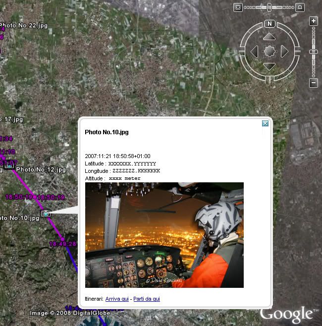
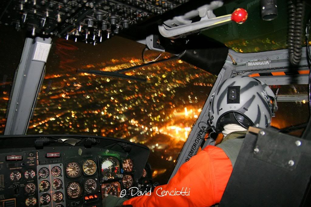
Quelle che seguono sono le foto di un volo notturno a bordo dell’AB.212ICO “Tiger 04″ impegnato in una SAR mare nel Golfo di Napoli, una missione addestrativa cui ho potuto prendere parte nell’ambito di un servizio giornalistico che verrà pubblicato nel numero di marzo di RID. Ho creato un .kmz fittizio con un’ipotetica rotta seguita dal velivolo al solo scopo di “agganciare” una foto ad uno degli ipotetici punti del percorso e dimostrare le notevoli opportunità offerte dal GPS logger in termini di Geotagging (prima immagine, screenshot da Google Earth).


 That’s a weird place to install a (handheld) GPS device. The image in this post was published by the official Twitter account of the Russian «Strizhi» (Swifts) aerial display team. The team fly 6 Mig-29


